HydroPol2D Case Builder
The HydroPol2D Case Builder prepares a complete, ready-to-run model case from public global data. You choose a city or a catchment. The Builder draws the model area, downloads and aligns the maps, prepares the rainfall and weather, and checks the case before you run it. It writes cases for HydroPol2D-MATLAB and for HydroPol2D-Python, the model engine inside HydroPol2D Studio.
This section describes Case Builder 0.1.0, the first licensed release (a test version), for Macs with Apple silicon and for Windows (64-bit).
The Case Builder is a proprietary product. To get a license, write to Marcus N. Gomes Jr. at marcusnobrega.engcivil@gmail.com. Install and license explains the steps.
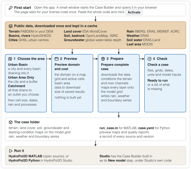
Figure 1. The path through the Case Builder. The public data feed the preview and the complete case. The case folder runs in HydroPol2D MATLAB or in HydroPol2D Studio.
What it prepares
| Step | What the Builder does |
|---|---|
| Model area | Three ways to choose it. Urban Basin: a city and every basin that drains into it. Catchment: one outlet and the watershed above it. Urban Area Only: the built-up area and a buffer around it. |
| Cost preview | Before any large download, it shows the area, the number of grid cells, the data to download and the size of the saved results. |
| Terrain and rivers | Terrain at the model resolution, conditioned for flow with HydroBathyDEM, with river widths and depths. |
| Maps | Land cover, soil texture, depth to bedrock, initial groundwater and soil water, and leaf area index. |
| Rain and weather | One rainfall product per case (IMERG, ERA5, MSWEP or AORC) and ERA5 weather. |
| Boundaries | Outlets with critical flow by default. River inflows (GloFAS) and coastal water levels (GTSM) where they apply. |
| Check | A preflight check of the files, grids, dates, units and required inputs. |
| Run | It writes the case for MATLAB, Python or both, and it can start the run and show its progress. |
A case that passes the preflight check is complete and consistent. That alone does not show that the model is accurate for a new place. Calibration and comparison with observations remain necessary.
Data sources
| Variable | Source |
|---|---|
| City boundary | GHSL Urban Centre Database R2024A |
| Basins and rivers | HydroBASINS v1c (level 12) and HydroRIVERS v1.0 |
| Terrain | FABDEM v1.2, or your own DEM |
| River geometry | HydroBathyDEM |
| Land cover | ESA WorldCover |
| Soil texture | OpenLandMap USDA texture classes |
| Depth to bedrock | Shangguan et al. (2017) |
| Initial groundwater | Fan et al. global water-table depth |
| Initial soil water | ERA5-Land |
| Weather | ERA5 |
| Leaf area index | MODIS MCD15A3H |
| Rainfall | IMERG, ERA5, MSWEP or AORC (United States), chosen per case |
No Google Earth Engine account is needed. Some sources need a free account of your own: Data sources and accounts lists them.
How it fits with Studio and MATLAB
- In HydroPol2D Studio, the New model wizard uses the Builder's preparation steps to make a model from a location on the map. See Building a model. If you have Studio, you do not need the Builder as well.
- The standalone Builder adds the full set of options: the three kinds of model area, the cost preview, the preflight report, and runs in MATLAB.
- With HydroPol2D-MATLAB, the Builder writes a MATLAB case with a
run_case.mscript that runs it. See the model-building workflow for how the Builder, the models and calibration work together.
How you use it
- a local app that opens in your web browser, with Prepare a case, Check a case and Python and command line pages,
- a command line, for scripted and repeated builds.
In this section
- Install and license: download, install, enter the license code.
- Choose the model area: Urban Basin, Urban Area Only and Catchment.
- Case settings: grid, dates, rain, processes, rivers, outputs and folders.
- Preview and cost: the domain map and the size of the case before any download.
- Prepare a case: the complete build and what is in the case folder.
- Data sources and accounts: Copernicus, NASA Earthdata and MSWEP.
- Check a case: the preflight check.
- Run the case: in HydroPol2D MATLAB or in HydroPol2D Studio.
- Command line: the same cases from a terminal.
- Troubleshooting: messages you may see and what to do.
Current limits
- Version 0.1.0 is a test version for Macs with Apple silicon and Windows (64-bit).
- The app does not download HydroPol2D Python. Run Python cases in HydroPol2D Studio.
- MSWEP rainfall needs prior approval from GloH2O.
- AORC rainfall covers the contiguous United States only. GTSM coastal water levels end in 2024.
- Albedo is a single value (0.25) in the current version.
- Storm drains, reservoirs and event calibration are not added automatically.