Ecosystem Architecture
HydroPol2D uses one versioned mesh package across its MATLAB and Python implementations. This prevents each solver from rebuilding geometry or interpreting mesh properties differently.
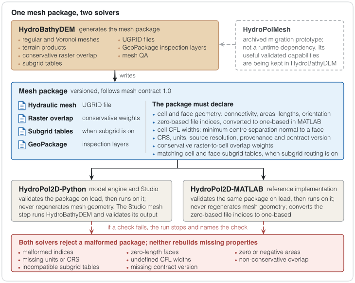
Figure 1. HydroBathyDEM writes one versioned mesh package, which HydroPol2D-Python and HydroPol2D-MATLAB both validate and run on. A package that fails a check is rejected, and neither solver rebuilds missing properties.
Repository responsibilities
| Component | Responsibility | Candidate version |
|---|---|---|
| HydroBathyDEM | Production generator for regular and Voronoi meshes, terrain products, conservative raster overlap, subgrid tables, UGRID, GeoPackage inspection layers, and mesh QA. | 0.4.0rc1 |
| HydroPol2D-Python | Python model engine and Studio. It validates and consumes the mesh package; it does not regenerate hydraulic mesh geometry. | 0.9.0rc2 |
| HydroPol2D-MATLAB | MATLAB reference implementation and compatible consumer of the same mesh package. | 1.19.0-rc2 |
| HydroPolMesh | Archived migration prototype. Useful validated capabilities are being retained in HydroBathyDEM; it is not a production runtime dependency. | prototype |
The stable MATLAB v1.17.0 release remains the numerical reference while the
coordinated release candidates complete parity and long-duration checks.
Shared mesh contract
Mesh contract 1.0 requires the package to declare:
- cell and face geometry, connectivity, areas, lengths, and orientation;
- zero-based file indices, converted explicitly to one-based MATLAB indices;
cell_cfl_width_m, defined from the minimum centre separation normal to a face;- CRS, units, source resolution, provenance, and contract version;
- conservative raster-to-cell overlap weights;
- compatible cell-level and face-level subgrid tables when subgrid routing is enabled.
Both solvers reject malformed indices, zero-length faces, zero or negative areas, missing units or CRS, undefined CFL widths, non-conservative overlap, incompatible subgrid tables, and a missing contract version. They do not silently reconstruct missing mesh properties.
Subgrid formulations
The following options solve different representations and are not aliases:
| Option | Intended representation |
|---|---|
| Neal channel | Rectangular channel embedded in the structured raster grid; supported with local-inertial routing. |
| Structured lookup subgrid | SFINCS-style depth-dependent cell and face lookup tables on a structured grid. |
| Voronoi subgrid | Area, wetted-perimeter, and conductance relations on an unstructured Voronoi mesh. |
Legacy names are accepted only by case migration. Incompatible combinations must be corrected before a simulation can start.
Release status
The release candidates are integration builds, not final coordinated releases. Final publication requires clean-clone installation, MATLAB-Python comparisons on identical mesh and hydrologic inputs, the Pune 2 h, 6 h, and 12 h runs, and passing scientific, Studio, lint, type, and provenance checks.